

NARAKA
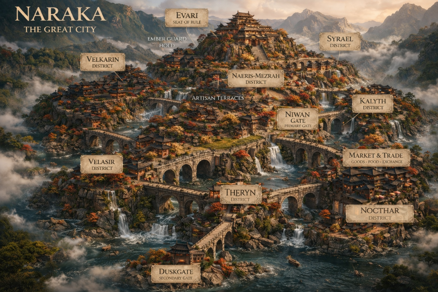
Map not to scale. Illustrated by local realm cartographers.
MAP KEY
Seat of rule within Naraka. The palace rises at the highest elevation of the city and serves as the political center of the realm.
The central district surrounding Evari. It is the highest inhabited tier of the city and forms the political heart of Naraka.
Primary gate of Naraka and the most frequently used point of arrival. Positioned near Evari, it connects directly into the central terraces and daily flow of the city.
Secondary gate of Naraka, set farther from the palace at lower elevation. It sees less traffic and serves as a quieter outer point of passage.
Structured commercial quarter positioned along the lower terraces near the Ember Guard Hold. Built into a distinct canal-bound mound, it serves as the primary hub for goods, food, and exchange within Naraka.
Central working terraces carved directly beneath Evari within the Naeris–Mezrah District. These stepped levels house controlled craft production and refined trades integrated into the city’s vertical structure.
Enforcement stronghold within the city, positioned along the lower terraces. Its presence marks authority, protection, and watch over key passages through Naraka.
Mid-elevation western district built along a broad terrace slope. It connects upward toward the central district and outward toward lower canal routes.
Upper eastern district positioned just below Evari’s summit level. It is one of the closest districts to the central palace outside the Naeris–Mezrah core.
Lower central district positioned along key bridge crossings. It connects multiple terraces and serves as a transitional hub between upper and lower elevations.
Mid-to-upper elevation district situated along the eastern rise. It is connected to surrounding terraces by elevated bridges and cascading waterways.
Lower elevation district positioned near the outer canal basin. It connects directly to the extended bridge route leading toward Duskgate.
Lower western district built across its own stone rise. It is heavily defined by bridge connections and canal edges separating it from adjacent terraces.
Narrow engineered canals divide Naraka into clustered terraced mounds rather than a single landmass. Water moves through the city in controlled channels, falls, and basin routes, with fish visible throughout the waterways.
Signature stone infrastructure of Naraka. Multi-arch bridges connect the city’s separate rises and terraces, allowing movement across canals while emphasizing the city’s dramatic elevation shifts.